 |
| Lyell Fork of the Tuolumne |
|
It took an early start at 5:40am from Yosemite Riverside Inn to reach Tuolumne Meadows just as the sun cast its first light into the valley. We drove through the campground and then over to the Tuolumne Meadows Lodge where hikers park their wheels and stash food items, safely away from cars, in bear-proof boxes.
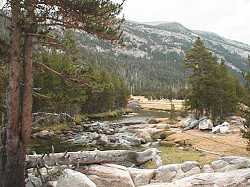
We started at 8:20am under clear blue skies, first crossing the Dana Fork and then the Lyell Fork of the Tuolumne River where we joined the John Muir and Pacific Crest Trail headed southeast up the canyon.
This trail, the river and the canyon are like 'ground zero' to me. It's the place where I first started training as a trouthunter during the early 1950's. Back then, I would follow Dad, toting a flyrod which must have been four times my length. Spincasting outfits had not yet become popular like they are today. We walked 5 or 6 miles up this canyon many times, camping, hiking and fishing, but I had not returned to enjoy this territory for almost 50 years.
Headwaters of the Tuolumne River form high up on the slopes at the end of Lyell Canyon and that's what we've come to see. At 13,144 feet, Mt. Lyell is the highest point in Yosemite National Park, and home to California's second largest glacier which clings to its northern flank. Mt. Lyell and the glacier will not come into view until we walk almost 8 miles into the canyon. (see map below)
Our walk provides some of the conditioning I need for a more strenuous adventure, a planned hike over the Sierra Crest to McCabe Lakes, and further on to Roosevelt Lake. Because of the distance we plan to cover on this day-hike, I anticipate little time for fishing, but I brought the fly rod along anyway.
|
It was strange returning to an area I hadn't seen for such a long time. Some features seemed vaguely familiar to me, but it was the sense of smell that really struck a chord in me. Every region in the High Sierra may have its own distinct aroma, based on the unique mix of vegetation, minerals and moisture. I think we lose track of this perception in urban areas where exhaust fumes distort every one of our senses. By mid-morning, storm clouds were starting to form and it appeared the weather might turn threatening.
After Labor Day, when the meadows around 9,000 feet elevation are showing their fall colors, you won't see many folks up here on the trail -- at least not as many as you would find during the summer months when this stretch of the John Muir - Pacific Crest Trail becomes quite popular.
|
After hiking a few hours, we encountered a college-age youth coming down the trail carrying a fishing rod. As one who strives to know more about the local fishery, I began interrogating. Yes, I could expect to catch Brookies and Brown trout in Lyell Fork, and also in Ireland Creek, still ahead on our route. It turns out this fellow was one in a party of four who had just spent an entire week based at 'Cable Camp' enjoying the fish in nearby streams. Next, his uncle came down the trail with a hickory walking stick that stood taller than me. It was Charlie, a mountain of a man who carried a huge pack covered by a Levi jacket. Charlie, looking down on me, noticed the cigar pack tucked into my shirt pocket, so he promptly brought out one of his own -- and we both lit up. I wanted to learn what they had been eating so I asked, "oatmeal?" "Nope, cornmeal," came the reply. (you can make a lot of stuff with cornmeal). "Bacon?" I asked... "yep, and a whole lot of trout!" Then a couple, Charlie's brother Dave and his sweetheart Ellie came into view. Maybe I ask plenty of questions, but I wanted to know where else they had fished in the region. They spoke of several trips from Tuolumne Meadows to Young Lakes, and beyond to Roosevelt Lake -- the later being the very target of my next adventure.
It was great to hear first-person accounts from folks who were not just day-hikers -- those who drive right up to a stream and pick off stockers (trout from fish hatcheries, planted in the streams), then return to their motel room for a comfortable night's stay. Dave and his pals were interested in finding another route to the remote Roosevelt Lake -- and they were considering the same path I had been investigating from Saddlebag Lake just two weeks earlier. I let them know where a web page with photos describing my recent adventure could be found, and we visited a few minutes more, then departed in opposite directions.
|
Along the trail, we meet the Lyell Fork at a place where a large slab of granite tries to hold back the stream. But water always strives to be at sea level, so it invariably forces its way over, around or through such obstacles, creating stunning landscapes in the process.
Granite barriers like these are responsible for building the meadow which extends nearly 10 miles up the Lyell Canyon in a series of terraces. From one end of the canyon to the other, there's only a few hundred feet difference in elevation, so our ascent up the trail is rather gentle. However, when each of the 'ups and downs' over the distance of the trail are all combined, it adds up to about 1,000 feet of elevation gain and loss.
|
Looking back toward our starting point, the meadow unfolds and reveals a stream meandering along, protected in places by willows providing excellent cover for trout. This view shows the classic form of a glacial-carved canyon, characterized by sides which curve down to the valley floor. River-cut canyons can be identified by their "Vee" shaped structure.
I can hold a 4 mph walking pace for about 20 minutes, and 3 mph rate for another 20 minutes. By the time I've walked for an hour, my pace may be down to less than 2 mph and then it's obvious that a short rest is needed. After relaxing for 10 or 15 minutes (which could include trouthunting), I'm fully recharged and ready to go on.
Lee Hilarides, co-owner of Yosemite Riverside Inn (near the Park entrance), discovers a tree displaying evidence of black bear activity. Bears are King in Tuolumne Meadows and apparently, a large male bear left his mark on this tree to let rivals know about his size and power, and to issue a warning against intruding on his turf.
|
Have a closer look
Those claw marks are 8 feet up the trunk, and were probably gouged in by a bear standing upright. Bears tend to avoid contact with humans -- except when your food is at stake.
We never mess with 'da bears. They can run farther and much faster than us, and climb trees quicker and higher than you could ever hope to go. |
|
All animals in the forest are wild and unpredictable. In most cases, there's little to fear if you keep your distance and show respect. Never, under any circumstances, try to feed or befriend the animals. Doing so only puts you at risk of serious injury or death. Animals can grow dependent on humans for food and lose their fear of you, as well as their natural ability to find food for themselves. Be content with viewing them from a good safe distance.
|
And here's a nice fat finny friend who fell to temptation. Trout are real good food and a fine catch it will be to join us for lunch.
Keeping up the pace and resting as needed, only a half hour or so was spent trouthunting. |
|
With skies growing ever darker, here's a place where 13,144' Mt. Lyell and its glacier can be seen from the stream.
|
At this point we've walked 7.8 miles up the Lyell Fork Canyon and here at 2:30 in the afternoon, it's time to turn and start back. We certainly wanted to stay a few days, or perhaps move along to someplace else, but this was a planned day-trip with a comfortable bed waiting for me back at Yosemite Riverside Inn. Darkness starts setting in around 7:00pm and there's another 7.8 miles to be retraced under threatening skies.
|
It's raining lightly and we're getting wet -- not drenched. Looking back, we can see (on the left) where we've just been. Potter Point dominates this photograph and marks the place where a trail branches off (to the right) and follows Ireland Creek up the canyon to Ireland Lake. It's after 4 pm and we haven't yet reached the half-way point.
Moving down the canyon, thunder crackles overhead and echoes from the granite walls. In this region, mountain generated storms are not uncommon at this time of year. Sometimes they're brief, and sometimes wind, rain, thunder and lightning can go on for hours. There's no way of telling what may happen, so if you plan to be out for more than a day, you should be prepared for anything, including snow.
|
There's time for another rest stop and what place could be better than this? Massive chunks of granite have been worn down and shaped by the forces of meltwater from the Lyell Glacier to a point where they resemble soft fluffy pillows left by a stream where giants paused to rest. Well, maybe not but clearly, they do show great form.
A few more miles peel away and by 7:00pm, we've back at the car to complete the 60-mile ride to Yosemite Riverside Inn. The day figures out to be 3.5 hours driving, 8.5 hours hiking and about 3 hours with a combination of fishing, resting, eating, and recording the views you've just seen here.
There are four visitor centers in Yosemite National Park. The Valley Visitor Center, located in Yosemite Valley is the largest and most comprehensive in terms of displays, books, postcards and maps. The Big Oak Flat Information Station, Wawona Information Station and Tuolumne Meadows Visitor Center are open on a more limited basis.
From the West: Take Hwy 120, the Northern Yosemite Highway, to the Big Oak Flat entrance to Yosemite National Park. Continue on Hwy 120, driving 9 miles east to the junction of Tioga Pass Road. Turn north at the Tioga Pass Road and drive 39 miles east on Hwy 120, arriving at Tuolumne Meadows.
From the East: Take Hwy 395 to Hwy 120, the Tioga Pass Road, and turn west. Drive 25 miles west from Hwy 395 on Hwy 120, arriving at Tuolumne Meadows.
FOR ADDITIONAL INFORMATION:
| Public Information Office Yosemite National Park P.O. Box 577 Yosemite, CA 95389 Phone (209) 372-0265 |
Recommended Lodging |
The National Park Service: Yosemite National Park